Ontology of geographic literacy: различия между версиями
Материал из Поле цифровой дидактики
Patarakin (обсуждение | вклад) Нет описания правки |
Patarakin (обсуждение | вклад) Нет описания правки |
||
| Строка 4: | Строка 4: | ||
|Environment=genAI, Graphviz | |Environment=genAI, Graphviz | ||
}} | }} | ||
<graphviz> | |||
digraph geographic_literacy { | |||
rankdir=LR; | |||
node [fontsize=10, shape="none"] ; | |||
subgraph cluster_GeographicLiteracy { | |||
label="Geographic Literacy"; | |||
GeospatialThinking; | |||
CartographicDesign; | |||
GeospatialData; | |||
} | |||
---- | GeographicLiteracy -> GeospatialThinking; | ||
GeographicLiteracy -> CartographicDesign; | |||
GeographicLiteracy -> GeospatialData; | |||
GeospatialThinking [label="Geospatial Thinking\nThe ability to analyze and\n solve problems using \ngeospatial data and tools"]; | |||
CartographicDesign [label="Cartographic Design\nThe ability to create effective maps\n and visualizations that \ncommunicate geographic information"]; | |||
GeospatialData [label="Geospatial Data\nThe ability to access, evaluate, and use\n various forms of geospatial data"]; | |||
SpatialAnalysis [shape=box, label="Spatial Analysis\nThe ability to use spatial data\n to identify patterns and relationships"]; | |||
MapMaking [shape=box, label="Map Making\nThe ability to create maps that \naccurately represent geographic data"]; | |||
GeospatialDataManagement [shape=box, label="Geospatial Data Management\nThe ability to collect, store,\n and manage geospatial data"]; | |||
GeospatialThinking -> SpatialAnalysis [label="hasSkill" fontsize=9]; | |||
SpatialAnalysis -> Intermediate [label="hasLevel" fontsize=9]; | |||
CartographicDesign -> MapMaking [label="hasSkill" fontsize=9]; | |||
MapMaking -> Advanced [label="hasLevel" fontsize=9]; | |||
GeospatialData -> GeospatialDataManagement [label="hasSkill" fontsize=9]; | |||
GeospatialDataManagement -> Intermediate [label="hasLevel" fontsize=9]; | |||
} | |||
</graphviz> | |||
== in Russian == | |||
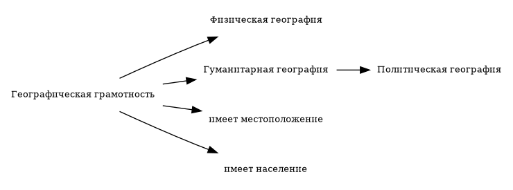
<graphviz> | |||
digraph Ontology { | |||
rankdir=LR; | |||
node [fontsize=10, shape="none"] ; | |||
GeographicLiteracy [label="Географическая грамотность"] | |||
PhysicalGeography [label="Физическая география"] | |||
HumanGeography [label="Гуманитарная география"] | |||
PoliticalGeography [label="Политическая география"] | |||
GeographicLiteracy -> PhysicalGeography | |||
GeographicLiteracy -> HumanGeography | |||
HumanGeography -> PoliticalGeography | |||
hasLocation [label="имеет местоположение"] | |||
hasPopulation [label="имеет население"] | |||
GeographicLiteracy -> hasLocation | |||
GeographicLiteracy -> hasPopulation | |||
} | |||
</graphviz> | |||